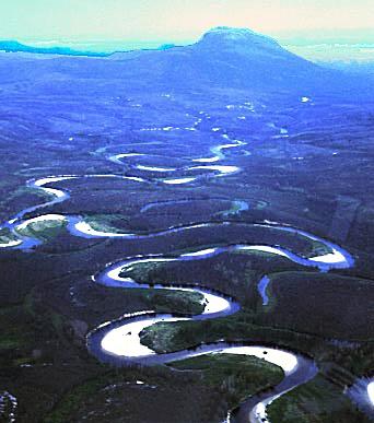
 Meanders and Associated Landforms What is it?A meander is a turning in a river or a change of its direction. Rivers erode the river bed from the outside of a meander where the river is faster and deposit sediment and silt on the inside of the meander where there is less energy. Eventually oxbow lakes can be formed in the erosion and deposition processes because two channels close up to form a separate lake. Meanders are mostly found further down the river where the plains are flat. Origins, perhaps?Meanders originate from fairly straight channels with developing pools and riffles. Usually there are obstructions found in a river that slow the fluvial flow down and the water has to flow over these which speeds speeds up the water flow. The higher velocity after the obstruction means there is more erosion happening, this area of greater erosion eventually turns into a pool and the slower area builds up from deposition of sediment carried in the river and turns into  a riffle. a riffle.What do meanders become?Pools are areas in a river where the water is deeper and the discharge is greater because of the lack of friction, whilst riffles are shallow areas of water where the discharge slows down because there is higher friction against the bed. The bending occurs because of the way the water erodes; the water has a second flow of a helicoidal (corkscrew) motion which starts to erode the sides of the bank. Once the bending starts to happen the river erodes more on one side of the bank and deposits more on the other making a sharper bend, once this bend grows too sharp most commonly in floods the bend turns into an oxbow lake where the river runs over the land instead of going round the bend. Human UsesMeanders offer a strategic advantage. A town or city could be located within the meander for defensive purposes. Today, cities are located in and around meanders for trade purposes. Boats and barges can access the town to some extent for some trade. However, trade is only possible if the river is deep enough. Meanders can be used by tourists for boating trips. Case Study: Shrewsbury
Shrewsbury is a county town lying on the river Severn in the West Midlands region and is home to around 71 000 inhabitants. It is placed inside a meander, and was originally a medieval market town. The meander was very helpful for imports and exports as well as travel in the medieval ages. Since 1990, Shrewsbury has experienced severe flooding problems becuse of its location - in 2005 the defense systems were increased dramatically to hold back the potential flooding. The land is very fertile due to all the layers of sediment and silt that have been forming over many years. Therefore, farming is a possibility on flood plains, around meanders. These crops must be resilient against high discharge in times of flooding. Page initially found at: Meanders and Associated Landforms (no longer available) | |||
