 |
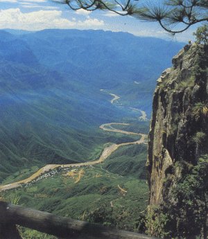
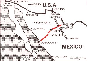
There are actually six separate canyons in the Copper Canyon system. Mexico established the Copper Canyon National Park (Parque Nacional Barranca del Cobre) to showcase this remote but beautiful area. The principal canyon is Urique Canyon, which is the one which is traversed by the Chihuahua al Pacifico Railroad. Eventually, all of the rivers which formed the Copper Canyons merge into the Rio Fuerte which continues across the adjacent state of Sinaloa, emerging near the City of Los Mochis on the Sea of Cortez.
- Urique Canyon - 6136 ft deep
- Sinforosa Canyon - 5904 ft deep
- Copper Canyon - 5770 ft deep
- Tararecua Canyon - 4674 ft deep
- Batopilas Canyon - 5904 ft deep
- Oteros Canyon - 3225 ft deep
 |
Landscape: Rivers born in the high pine forests have carved a 10,000 mile maze of spectacular steep-walled gorges into the volcanic rock of the Sierra Madre Occidental Mountain Range. Standing on a canyon rim surrounded by pine-oak woodland, you look down on giant cactus and tropical trees over 5,000 feet below. Watered by summer thunder storms, the canyon country is a virtual pallet of greens highlighted by the reds and yellows of the deciduous oaks in spring and fields of wildflowers in autumn.
People: The Chepe railroad made the canyons accesible for tourists to enter this area long inhabited by the reclusive Tarahumara Indians. These small, shy natives are famed for their long-distance running ability. Some 50,000 Raramuri ("the people of the swiftly running feet") — as they call themselves — live in caves and other primitive dwellings, much as their ancestors have for the last 400 years.
Copper Canyon
A Brief Summary of the Geologic History of Northern Mexico
Copper Canyon
Copper Canyon