Climate
 Variation
The climate of the Sahara has undergone enormous variation between wet and dry over the last few hundred thousand years. During the last glacial period, the Sahara was even bigger than it is today, extending south beyond its current boundaries. The end of the glacial period brought more rain to the Sahara, from about 8000 BC to 6000 BC, perhaps as a result of low pressure areas over the collapsing ice sheets to the north.
Monsoon Rains
Once the ice sheets were gone, northern Sahara dried out. But in southern Sahara, the drying trend was soon counteracted by the monsoon, which brought rain further north than it does today. The monsoon results from the heating of air over the land during summer. The hot air rises and pulls in cool, wet air from the ocean, which causes rain. Thus, though it seems counterintuitive, the Sahara was wetter when it received more solar insolation in the summer. At that time, there was a stronger tilt in Earth's axis than today, and perihelion occurred at the end of July.
By around 3400 BC, the monsoon retreated south to approximately where it is today, leading to the gradual desertification of the Sahara. The Sahara is now as dry as it was about 13,000 years ago. Marine dust records of the Arabian Sea and the central Atlantic Ocean, as well as a dust record from Jerusalem all indicate a more humid, vegetated Sahara during episodes of enhanced monsoon activity (commonly within interglacials), including the early Holocene, compared with drier glacial conditions (and late Holocene) in the Sahara.
Shifting Sands
The Sahara has one of the harshest climates in the world. The prevailing north-easterly wind often causes the sand to form sand storms and dust devils. Half of the Sahara receives less than 2 cm (0.79 in) of rain per year, and the rest receives up to 10 cm (3.9 in) per year. The rainfall happens very rarely, but, when it does, it is usually torrential after long dry periods that can last for years.
The southern boundary of the Sahara, as measured by rainfall, was observed to both advance and retreat between 1980 and 1990. As a result of drought in the Sahel, the southern boundary moved south 130 km (81 mi) overall during that period. Deforestation has also caused the Sahara to advance south in recent years, as trees and bushes continue to be used as fuel source.
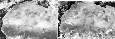
 The accompanying images (November 2000 on the left and September 2003 on the right) show dramatic darkening, pushing northward, along the southern edge of the Sahara, the result of exceptionally heavy rains in summer 2003. The same rains that have pushed back the desert region in the south were also responsible for the heat wave in Europe as the hot, dry air of a Sahara summer was pushed north into Europe.
The Niger River increased flow as much as eight times the typical amount for the rainy season. Flooding occurred in countries all along the southern borders of the Sahara region, as well as flooding further south in Nigeria. At least 100,000 people were affected and crops were damaged.
Excerpted and adapted from: Sahara, Changing Climate on the Sahara, Monsoon
The Sahara–East Mediterranean dust and climate connection revealed by strontium and uranium isotopes in a Jerusalem speleothem (Available from class readings)