SCHUUR LAB - ECOSYSTEM DYNAMICS RESEARCH
The Permafrost Thaw Gradient
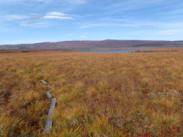
The thaw gradient contains three sites named minimal, moderate, and extensive thaw for the amount of vegetation change, active layer thickening, and thermokarst formation they have undergone due to different durations of permafrost thaw. At the extensive thaw site, permafrost thaw has been documented for the past two decades but likely began earlier. Extensive thaw has more shrubs than moderate and minimal thaw and has an undulating terrain with high, dry areas next to low, wet areas as a result of permafrost thaw. Next to moderate thaw is a 30 m deep borehole that has been used to measure permafrost temperatures since 1985. The goal of research at the permafrost thaw gradient has been to investigate the source and strength of feedbacks between permafrost warming and climate change. As permafrost soils thaw, their large carbon pools become vulnerable to microbial degradation, releasing CO2 into the atmosphere, which is a positive feedback to climate change. The thaw gradient has had ongoing monitoring of soil temperature, permafrost thaw depth, water table depth, and common substrate decomposition since 2004. CO2 fluxes were measured regularly from May through September from 2004 through 2010 with both static and auto chambers. During that same time period, radiocarbon measurements of ecosystem respiration were taken monthly. The thaw gradient is also where our eddy covariance tower is located. The eddy tower has been measuring CO2 fluxes since the summer of 2007.
 |
 |
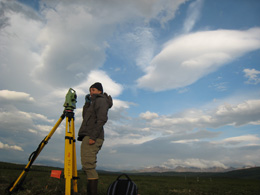
Surveying (photo by F. Belshe) |
Gradient field site (photo by C. Hicks) |
back to research


